
Sonar mapping of storage ponds offers safety and savings
Sludge Management
Sonar mapping of storage ponds offers safety and savings
Technicians, technologists, en- vironmental specialists and engineers in small boats have poked and prodded primary and secondary wastewater effluent ponds, cells and lagoons for years to ob- tain approximate depths to the sediment surface at discrete positions.
Acoustic sonar sediment distribution surveys are able to accurately and quickly measure volume and locate areas of sludge loading within an entire underwater area of a pond, cell or lagoon.
Sludge volume computations can be incorporated into a dredging/de-sludg- ing request for quote. This offers a cost savings to owners as there may not be any billing reductions from dredging companies, due to lower actual vol- umes.
PW Makar Coatings Inspection Ltd. conducts hydrographic bathymetric sur- veys in municipal wastewater lagoons from a manned, 10 foot aluminum boat with an outboard motor. It is equipped with a single beam echo sounder sys- tem, incorporating a three transducer ar- ray. Raw data is integrated and collected into an onboard computer system which is able to generate high quality bathym- etry sludge and sediment hydrographic surveys.
Navigation of the boat and sonar ar- ray is performed using precision GPS, keeping the survey system over a series of preplanned lines at an approximate spacing of five metre intervals.
Prior to launching the survey vessel, fall protection harnesses, personal flota- tion devices and vessel inspections are conducted. Recently, however, indus- trial health and safety representatives sought safer, alternative methods for collecting lagoon sludge data. This, plus the fact that some industrial ponds are simply too hazardous, toxic, or corro- sive to conduct conventional manned hydrographic surveys, meant another option was needed.
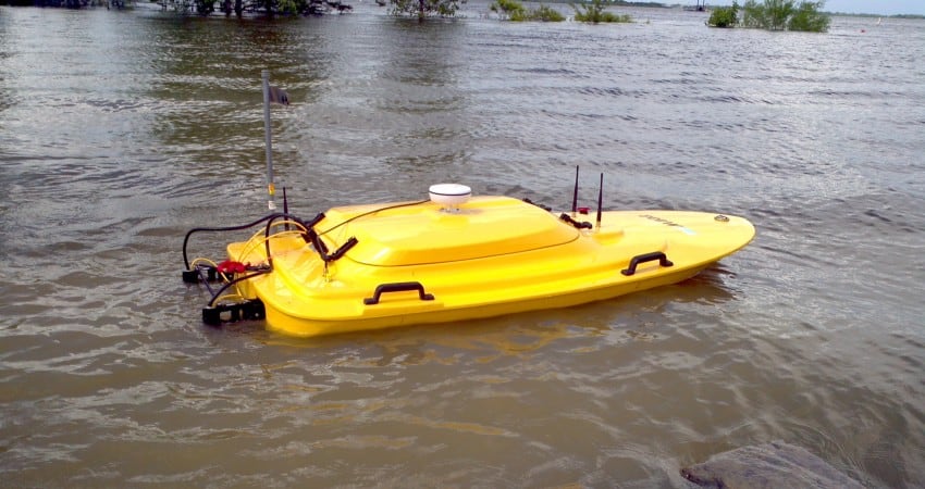
To remove operators from hazardous environments, PW Makar outfitted a 27
To remove operators from hazardous environments, PW Makar outfitted a 27 kg, nearly two metre long sonar vessel.
kg, nearly two metre long sonar vessel. While it might be mistaken for a remote control hobby boat, it conducts the same hydrographic survey process with the same equipment as a conventional manned survey boat.
It can be easily launched into indus- trial ponds, cells and lagoons, using a light weight pitman hydra-lift truck crane, or a long extended grapple pole.
The vessel’s position is monitored using a global navigation satellite sys- tem (GNSS/GPS) and an echo sounder, typically working at 33 kHz and/or 200 kHz, is used to precisely measure the depth under the boat. Acoustic pulses travel from the transducer in the vessel’s hull and reflect off of the storage pond bottom. The echo is received back at the transducer a certain time later. This time is directly proportional to the depth un- der the boat.
The operator remains on shore, viewing boat position, heading, and the completed survey track, at a distance of up to 1500 metres. Data is transmitted through the vessel’s long range wireless link. After collecting initial survey data, powerful hydrographic surveying soft
ware is used to generate a final product report from the raw sonar and GNSS/ GPS data.
By 3D plotting sludge and sediment maps, areas which are overloaded can be identified. These reports can be sub- mitted to various provincial ministries to verify compliance.
In addition, this technology allows industries and municipalities to conduct partial dredging. This cost savings tech- nique specifically targets sludge over- loading areas. By mapping out sediment and sludge loading, owners may realize additional storage capacity or reduce the use of chemicals and energy.
Information in the survey report can optimize storage performance and slow loading by redirecting intake piping, mixers or aerators. Installation of float- ing baffles/curtains across specific areas

52 | May/June 2014
Environmental Science & Engineering Magazine
of the pond, cell or lagoon, can be confi- dently installed as heavily loaded areas are known.
For more information, contact Paul Makar. E-mail: paul.makar@cogeco.ca

John Hinde
Please email me your sonar mapping product information & boat pricing
Thanks