
Sea Link Dive Article
Role
Specialty Devices role in this cruise involved contributions to the design and building of portions of the PFA, recovery of the PFA, site investigation and mapping efforts of the overall site and in the modification, deployment and recovery of the WHOI/NC mooring. Each of these efforts will be discussed below. Participation in one of the dives on this cruise was very useful in viewing and gaining an understanding of the site characteristics. This knowledge will be very valuable in the design of the SSD for operation at the MC118 site. In addition, participation in the rest of the cruise allows a better understanding of the needs of other researchers in the performance of experiments on the seafloor and how modifications can be made to the SSD design to better meet these needs.
Site Investigation
-

Dive Targets

Dive Log For Sea Link Dive # 3066 September 12, 2006
Dive Crew
Sub Operator: Phil Santos in front sphere and Craig in back chamber
Scientific Crew: Paul Higley in front sphere and Bob Woolsey in back chamber
Objectives

Holes left from taking 6 cores
- Recon the northern area designated Target #5
- Locate and recover the Osmo sampler from the top of the Pore Fluid Array (PFA),
- Take 6 push cores in and around a V mat. two cores to be taken in the mat, two core to be taken at the edge of the mat and two cores to be taken outside of the mat. Each set of 2 cores are to have each core pushed in before either core is retrieved.
- Take two stainless steel push cores
- Locate if possible the Geophysical Array (GPA)
- Deploy the bio-activated galvanic electrical generator on the sea floor and ideally at an active vent area.
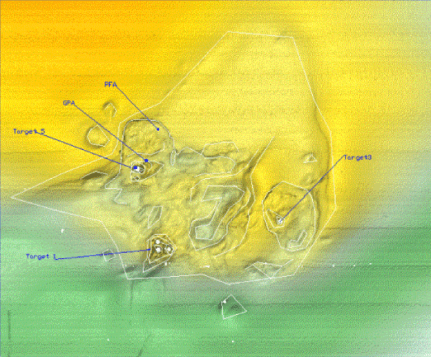
The primary objectives of the dive are to verify the location of the features of target 5 are indeed at the plotted position of target 5 and to locate and retrieve the PFA.
Target Location
Equipment onboard at start of the dive
Dive target location;
Target location for the start of the dive is Target area #5
Location of Target area # 5 is 280 51’ 21.780” N
0880 29’ 36.096” W (re; WGS84)
This location is as per the WHOI background chart corrected from the C&C bathymetry and verified with SDI’s DEEP SEE video camera data.
The PFA and GPA are believed to be 100 to 300 feet to the NE of this target area 5
Location of the PFA 280 51’ 28.273” N and 0880 29 33.247” W (re; WGS84)
This location is a result of a 6 point triangulation on a release responder at the time of installation.The standard deviation of triangulation coordinates was approximately 5 meters for this location. This PFA should have at least 6 feet of 24” square cross section steel and concrete weight above the bottom and a green 24” square by 20” high sampler box on top of the concrete weight. The weight bow section
could be several feet above the bottom and supported on an exposed portion of a 30 pipe with the pore fluid entry ports distributed along its length.
Location of the GPA 280 51’ 23.065” N 0880 29’ 33.247” W (re; WGS84)
This location is estimated from a 6 point triangulation that did not converge well. The standard deviation for this position is estimated at 30m
The GPA used a similar bow weight but may be laying on its side so the total height could be 18” to 24” above the sea floor. If this weight section is standing some care should be taken to assure it does not fall over with the sub in the vicinity. The GPA data logger is an 18” long 4” diameter housing with 2 circular wet mating connectors at one end, a handle on the opposite end and a handle on the top. The GPA data logger is removed with a pull or push to dislodge the connectors. The weight in water of the GPA data logger is less than 4 lbs.
Dive Operations
-

Exposed portion of the PFA sample
Launched and submerged at 0820 EST
During descent the surface relayed that we appeared to be off target and going west. The sub motored east during descent and later was informed the navigation appeared unstable.
0909 EST touch down. Bottom relatively flat mud little sign of shell or other indication of Gas Hydrate activity.
Scanning sonar showed no close targets It should be noted there is a constant return on the 750 foot range at about 700 feet extending from 020 through 080. This is an artifact and not a valid return.
The depth at touch down was 2916 to 2918 feet. There was no indication of bearing from the surface to our target so we proceeded North to shallower water based on the known bathymetry. Several light targets appeared on shorter ranges (250 ft. range) only to disappear when approached. Progress was generally North estimated from 100 to 300 feet. No navigation was available from the surface.
A V. matt appeared and some shells after about 20 minutes of bottom time. The set of 6 cores were taken at this point. We assumed that a position could be determined during the time we were stopped to take the cores. Cores 1 and 2 were inside the mat, core 3 and 4 were taken at the edge of the mat and cores 5 and 6 were taken approximately 6 to 8 feet outside of the mat. Number 1 Niskin bottle was tripped at this site and 0936 EST.
Position information on this location were requested from the surface but apparently the hydraulics used for the arm disrupted the positioning and no location could be supplied.
A possible low area defined by near and far lines of returns was detected at about 300 to 400 feet to the N and NW. Another closer return was detected to the east and we proceeded to the east maybe 80 to 160 feet. No reason for the return was located. We transited west an unknown distance and began to detect the apparent ridges possibly defining a low area to the north.
We transited North and unknown distance estimated at 100 to 300 feet and possibly 50 to 100 feet west. We started to pick up shell and mat. We found new looking vent holes from 1 to 4 foot in diameter and 1 to 3 feet deep. We found rocks 1 to 3 feet high and 30 to 40 feet long. One crater was found approximately 10 to 15 feet deep. No bubbles were seen.
We turned east, to North, to west a short distance and back east to navigate through the rocks and crater. Proceeding north over more level terrain we started seeing a small reflection intermittently visible at 200 feet on the 250 foot range. At 120 foot range the block was appearing regularly and at 100 feet the block was constantly showing on the sonar. At about 30 to 40 feet the PFA appeared. The block was approximately 6 feet above the sea floor and nearly perfectly upright. The release chain to the lift bridle had fallen into the OSMO sampler and jammed the bridle from falling down to the side of the weight block. The valve side of the sampler box was on the northern side of the PFA array. Note the position of the valve and the fallen bridle in Figure 5 below for proper installation of replacement sampler boxes.
The Sub pushed the weight block to test its stability and then used a fork on the front of the sub to push the bridle to the opposite side thus clearing the chain and allowing the bridle to fall properly to the side of the weight block.
The sub was positioned against the weight block and the four securing pins pulled to release the sampler box from the mounting plate. The valve on the sampler box was rotated approximately 30 degrees clockwise to a closed position as indicated on the side of the sampler box.
The sampler was then lifted from the weight block and stored aboard the Sub. The bottom time at this point was about 2 ½ hours. The area around the PFA was covered with a light distribution of shells and mat. The remaining 5 Niskin bottles were tripped at this location and the biologically enhanced galvanic electrical generator was deployed at this site. The two remaining push cores were taken in a mat area at this site.
The sub returned to the surface at approximately 12:30 EST.
WHOI/ NC mooring deployment
Changes to the mooring to accommodate the capabilities available on the R/V Seaward Johnson.
The original mooring design of the WHOI/NC mooring included 20 and 50 meter Nilspin plastic jacketed wire sections with up to 2000 lb. tension during deployment. As there were no winches available to wind the mooring on a winch drum, the mooring was to be deployed with extra flotation on the upper portion of the mooring and in an anchor last free fall fashion. The was modified to allow installation over the side of the R/V Seward Johnson using the ship upper deck crane. The extra flotation was to prevent the mooring from sinking from the surface. In this manner the mooring could be suspended from the surface in a safe manner, recovered and have the extra floatation removed, and then lowered with the hydro winch to the desired seafloor location. Lack of navigation to the desired precision in placing the mooring on the seafloor resulted in a lower and estimate position based on wire angle method of placement of this mooring on the seafloor.
Recovery of WHOI/ NC Mooring
September 14, 2006
The WHOI/NC mooring was deployed between the morning and afternoon Sub dives.
The Sub was onboard at approximately 12:30 and at about 13:40 the instruments on the mooring were ready to be deployed. The deployment was completed by 16:30.
September 16 2006
The acoustic release was triggered at 1208 and spotted off the starboard beam at 1221. Recovery was completed by 13:40